Norwich
Shoe Factories
in the 1950s
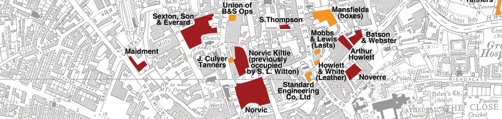
| Arthur Howlett | Fishergate | |
|
| Bally | Hall Road | |
|
| Barfield & Richardson | Starling Road | |
|
| Batson & Webster | Fishergate | |
|
| Bowhill & Elliott | London Street | |
|
| Buckinghams Shoe Shop | London Steet and Davey Place | |
|
| British United | Starling Road | |
|
| Chittock | Dibden Road | |
|
| Co-op/ CWS | Mountergate | |
|
| D MacLaren | Mousehold Lane | |
|
Edwards & Holmes | Drayton Road | |
|
| Florida Group | Dibden Road | |
|
| Howlett & White | St George Plain | |
|
| James Southall & Co | Crome Road | |
|
John Culyer & Sons | Duke Street | |
|
| John F Kirby | Pitt Street | |
|
| Mansfield Box Company | St Saviours Lane | |
|
| Meadows | Peacock Street | |
|
| Novic Shoe Company | St Georges and Vulcan Road | |
|
| Osoeasie | Northumberland Street | |
|
| P Haldinstein & Sons | Queen Street | |
|
| P. Segger | Botolph Street | |
|
| Pell Footwear | Mousehold Lane | |
|
| Ponds Shoe Shop | Castle Meadow | |
|
| R. Roberts | Fisher Lane | |
|
| S L Witton | Colegate | |
|
| S. Thompson & Son | Golden Dog Lane | |
|
| Sexton, Son & Everard | St Mary's Plain | |
|
| Shingler & Thetford | Pottergate | |
|
| Shorten & Armes | Esdelle Street | |
|
| Standard Engineering | Fye Bridge Street | |
|
Start-rite | Crome Road | |
|
| Thomas Bowhill & Hubbard | Heigham Street | |
|
| Trimfoot | Starling Road | |
|
| W H H Clarke | Northumberland St | |
|
| W H H Clarke | Sussex Street | |
|
| W. Hurrell | Magdalen Street | |
|
| Wards | Magdalen Street | |
|